- For your Kind Consideration:
- Vietnam War Map
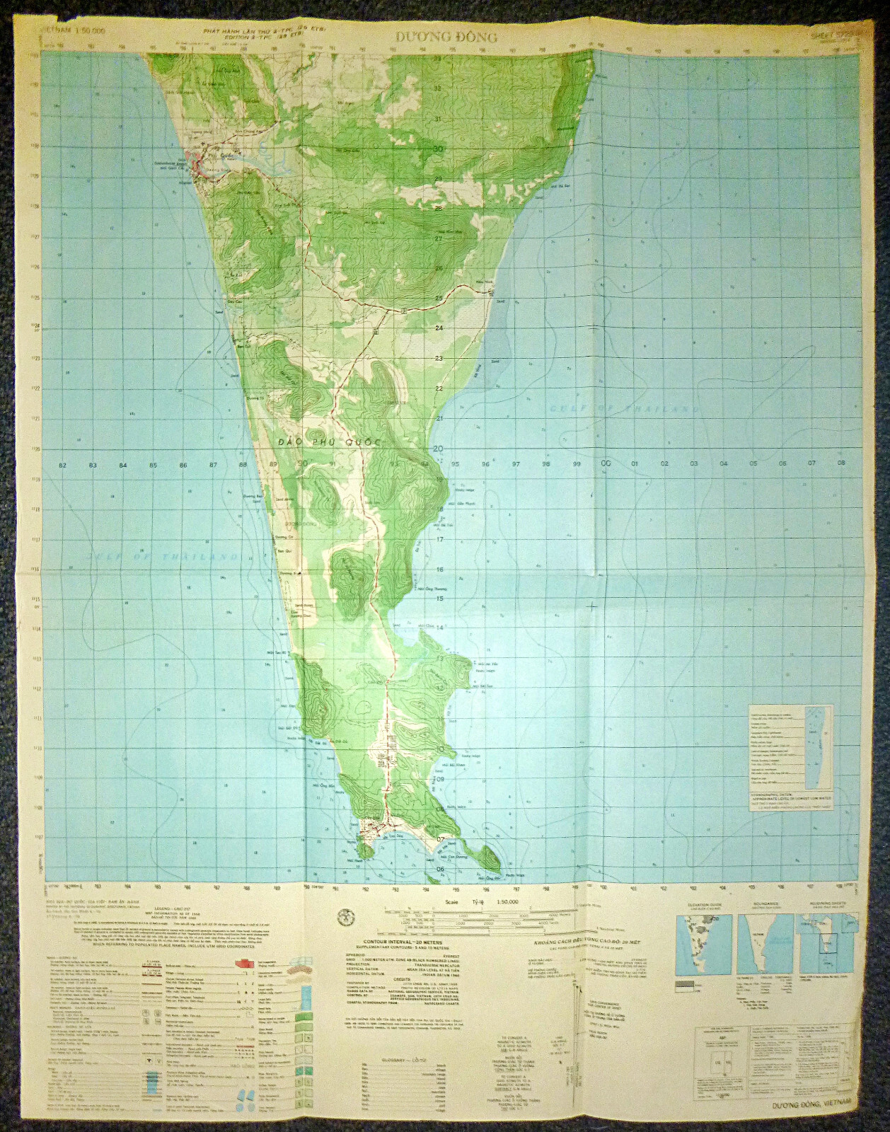
Duong Dong - Phu Quoc Island - Vietnam War Map
US Navy Operations - US NAVY SEALs Operations
Operation Market Time
Rare Map, Prepared 1968, Printed 1969 and captured at War\'s end by the Viet Cong and marked, Property of People of Vietnam, June 1975 (Two months after wars end).
Vietnam War MAP
- Measures - 29 x 22.5 inches ( 74 x 59 cms )
US MILITARY MAP - Rare Original
VIETNAM WAR
Extremely Rare, Fantastic Piece.
- Measures - 29 x 22.5 inches ( 74 x 59 cms )
- Original - Vietnam War Map
Duong Dong - Phu Quoc Island
During the Vietnam War, Duong Dong, the capital of Phu Quoc Island, and the surrounding areas, including the U.S. military bases at Cay Dua (Bai Cay Dua), became significant strategic points in Kien Giang Province, located in the Gulf of Thailand. These locations were crucial for both U.S. and South Vietnamese operations against the Viet Cong (VC) and North Vietnamese forces.
The U.S. established military bases at Duong Dong and Cay Dua in the mid 1960s. These bases served multiple purposes, including logistics, intelligence, and operations against VC activities in the region. The bases included airstrips used by the CIA and U.S. Special Forces for covert operations, supply runs, and to provide air support for ground forces.
In rural Kien Giang Province, the VC maintained a strong presence throughout the war, controlling much of the area and using it as a logistical base for operations in southern Vietnam. The lush landscape provided cover for guerrilla warfare tactics, complicating efforts by U.S. and ARVN forces to eliminate VC influence.
From 1968 to 1969, U.S. Navy SEAL teams operated in and around the peninsula, conducting reconnaissance missions, ambushes, and raids against VC forces. These operations aimed to disrupt enemy supply lines and gather intelligence on VC movements. SEALs leveraged their specialized training to navigate the coastal and riverine environments, often engaging in hit-and-run tactics that capitalized on the element of surprise.
The intensity of operations in the region continued until the early 1970s. As U.S. involvement in Vietnam began to decline, there was a shift in strategy, and many military installations were gradually abandoned. The bases at Duong Dong and Cay Dua saw a significant reduction in U.S. military presence, culminating in the official abandonment of U.S. bases in Phu Quoc by the end of 1972. The strategic focus had shifted as part of the broader \"Vietnamization\" policy, aiming to transfer responsibility for the war to South Vietnamese forces.
Throughout the war, the SEAL operations in Kien Giang Province and the surrounding areas highlighted the challenges of combating a resilient guerrilla enemy in a complex and rugged environment. The interplay between local control by the VC and U.S. military efforts underscored the difficulties faced by U.S. forces in achieving their objectives in the region.
Phu Quoc Island today.
Phu Quoc Island today is a popular tourist destination known for its stunning beaches, lush jungles, and vibrant marine life. Situated in the Gulf of Thailand, it is part of Vietnam\'s Kien Giang Province and has undergone significant development since the end of the Vietnam War.
The island is renowned for its natural beauty, attracting visitors with its clear waters, sandy beaches, and opportunities for snorkeling and diving.
The An Thoi archipelago, located to the south of Phu Quoc, is particularly famous for its picturesque islands and coral reefs.
In recent years, Phu Quoc has seen rapid economic growth and infrastructure development, particularly in the tourism sector. Numerous resorts, hotels, and entertainment facilities have been built, transforming the island into a major tourist hub. The government has invested in transportation infrastructure, including a new international airport, making it more accessible to both domestic and international travelers.
Culturally, Phu Quoc retains elements of its historical heritage, with traditional fishing villages and local markets offering glimpses into the island’s past. The production of fish sauce, a local specialty, remains an important part of the island\'s economy and culinary identity.

Related Items:
5729 ii - MAP - Phu Quoc Island - Duong Dong - Gulf of Thailand - Vietnam War
$272.00