"An Authentic Original Map Not A Reproduction"
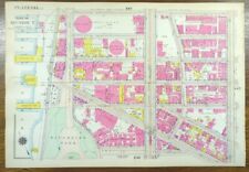
Offered for your consideration is a beautiful antique original map showing the Riverside Park neighborhood, bounded by the Hudson River to the west, Amsterdam avenue to the east, West 133rd street to the north and West 127th street to the south. On the reverse is a map of an East Harlem neighborhood, on the East River, as seen in the last photo. This antique 16 1/2" x 11 1/2" land and street map is in VERY GOOD condition with light tone and soil, from the Atlas of New York City, Borough of Manhattan ©1916 by G.W. Bromley, also known as the Land Atlas.
A copy of the title page is included with your purchase to verify authenticity.
FREE SHIPPING: Your map will be rolled in a plastic sleeve and shipped in a cardboard tube with USPS tracking.
Please view our happy customer response and buy with complete confidence.
Please view our other 1,000 plus maps for sale in our store.
We sell antique and vintage original maps only, no reproductions.
Thank you

Related Items:
Vintage 1916 HAMILTON HEIGHTS MANHATTAN NEW YORK CITY NY Land Map G.W. BROMLEY
$164.88

Vintage 1916 YORKVILLE MANHATTAN NEW YORK CITY NY Map CARL SCHURZ JOHN JAY PARK
$136.76

Vintage 1916 MARCUS GARVEY MOUNT MORRIS PARK MANHATTAN NEW YORK CITY Land Map
$200.88
