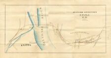
3 maps of the Easton Phillipsburg and the Morris & Essex Railroads. Larger map measures 27\" x 14 1/4\". Click on \"View Larger Image\" to see additional smaller size maps. The Morris and Essex Railroad was a railroad across northern New Jersey, later part of the main line of the Delaware, Lackawanna and Western Railroad. The M&E was incorporated January 29, 1835, to build a line from Newark in Essex County west to and beyond Morristown in Morris County. The first section, from Newark west to Orange, opened on November 19, 1836. Under an agreement signed on October 21, the New Jersey Rail Road provided connecting service from Newark east to Jersey City via the Bergen Hill Cut. The original connection between the two lines was in downtown Newark; the M&E turned south on Broad Street to meet a branch of the NJRR at Market Street. Service to Paulus Hook in what is today Jersey City commenced on October 14, 1836 and passengers could transfer to the Jersey City Ferry and cross to lower Manhattan at the nearby ferry slips. On January 1, 1838, the M&E was extended their route to Morristown. On October 29 of that year, an agreement was signed to move the NJRR connection to the foot of Centre Street (via the northeast side of Park Place, to the NJRR alignment along the Passaic River), and the track on Broad Street was removed. Through car service began August 1, 1843, with horse power used along the streets, between Broad Street station and the foot of Centre Street. Continuations opened west to Dover on July 31, 1848, Item ordered may not be exact piece shown. All original and authentic.

Related Items:

California 3D Raised Relief Map Hubbard Scientific Vintage
$149.99
3 Maps of the Easton Phillipsburg and Morris and Essex Railroads - Miscellaneous
$300.00

Lot of 15 - AAA States Old Road Maps - Group 3
$15.95
