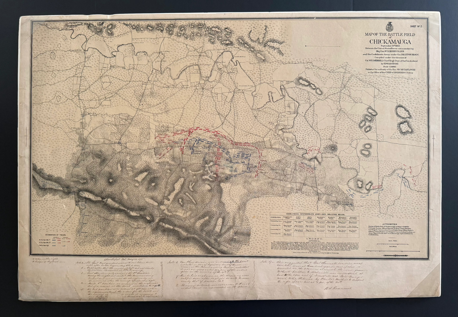
The large-format map [25 x 39] depicts the fighting of September 20, 1863, between Rosecrans’s Union army and General Braxton Bragg’s Confederate Army of Tennessee. Published under the authority of the Secretary of War by the Office of the Chief of Engineers, it was compiled under Colonel William E. Merrill and drawn by topographical engineer Edward Ruger. Union positions appear in blue and Confederate positions in red.
Across the lower margin, Rosecrans added approximately nine detailed manuscript notes correcting the government’s placement and movement of troops. Writing as the battle’s commanding general, he discusses his headquarters at the Widow Glenn house, the positions of Sheridan, Wood, Van Cleve, Baird and Thomas, the movement of the Confederate left and the orders issued during the critical morning of September 20.
Rosecrans also modified the map’s legend to distinguish positions occupied during the night from those corrected at daybreak. One annotation begins:
“The Genl Headquarters was at Widow Glenn’s house until after battle began—say till 8 A.M.”
Another disputes the representation of the Confederate position, while additional notes explain the movement of Union divisions and the location of the army’s defensive line. The final correction is signed in full:
“W. S. Rosecrans”
The annotations are headed “San Rafael, Cal., May 22, 1890.” Their date is particularly significant: Congress established Chickamauga and Chattanooga National Military Park later that same year, while veterans and government officials were working to determine the exact placement of troops and monuments. Rosecrans’s markings may have been prepared as part of that larger historical review.
Chickamauga remained the defining controversy of Rosecrans’s military career. On September 20, 1863, an order intended to close a supposed gap instead opened a genuine breach in the Union line, allowing Longstreet’s Confederates to divide the army and drive much of it from the field. Rosecrans spent decades challenging accounts that he believed misrepresented his decisions. This map preserves his corrections directly upon the government’s official reconstruction of the battle.
Condition: Overall toning, old folds, scattered staining, creasing and marginal wear. Several tears enter the printed border, including a substantial closed tear and weakened area at the lower left. Portions of the handwritten annotations are faded or affected by folds, but the text remains substantially legible. Rosecrans’s signature is clearly readable. Please examine the accompanying photographs.
Far more than a signed map, this is Rosecrans’s personal response to the official record of his most consequential battle—a remarkable combination of cartography, firsthand testimony and Civil War history.
More info...
Map of the Battle Field of Chickamauga, September 20th, 1863, Between the United States Forces Commanded by Maj. Gen. W. S. Rosecrans and the Confederate Army Under Gen. Braxton Bragg
- Sheet No. 2
- Compiled under the direction of Colonel William E. Merrill, Chief Engineer, Department of the Cumberland
- Drawn by Edward Ruger
- Scale: 1:20,000
- Published by authority of the Secretary of War through the Office of the Chief of Engineers, U.S. Army
- Printed circa 1889–1890
The map shows the Union and Confederate positions on September 20, 1863, printed in blue and red. It identifies divisions, brigades, roads, farms, mills and terrain across the battlefield.
Rosecrans’s Annotations
Across the lower margin, Rosecrans added approximately nine extensive manuscript notes correcting or challenging the official representation of the battle. He dated the annotations:
“San Rafael, Cal., May 22, 1890”
One of the notes concludes with his full signature:
“W. S. Rosecrans”
The annotations are written in the first person and discuss decisions he personally made during the battle. Among the subjects addressed are:
- The location of Union headquarters at the Widow Glenn house
- The Confederate left flank as represented on the map
- Philip Sheridan’s position and movements
- Thomas J. Wood’s first and second positions
- Horatio Van Cleve’s division near Dyer’s field
- Absalom Baird’s line and its adjustment after daylight
- The location of George H. Thomas’s forces
- Union troop movements and orders during the crucial morning of September 20
Rosecrans also added symbols to the printed legend, explaining that certain troop positions were “taken in the night” and others “rectified at daybreak.”
These are not casual ownership notes. They constitute Rosecrans’s personal, detailed criticism of the government’s official reconstruction of the battle he commanded.
Historical Importance
The Battle of Chickamauga was fought September 19–20, 1863, and was the most significant Union defeat in the Western Theater. During the second day, Rosecrans issued an order intended to close what he believed was a gap in the Union line. The resulting movement created an actual opening through which James Longstreet’s Confederates attacked, dividing the Union army and driving much of it from the field.
The accuracy of troop positions and responsibility for the collapse became intensely controversial. Rosecrans spent much of his later life defending his decisions and disputing accounts that placed primary blame upon him. The National Park Service still describes the misunderstood gap and Rosecrans’s resulting order as the pivotal event of the battle.
The timing is especially noteworthy. Rosecrans made these annotations in May 1890, the year Congress established Chickamauga and Chattanooga National Military Park. The map may have been supplied to him for review as veterans and officials attempted to establish the historically correct placement of troops. That connection is a strong possibility, although it should be presented as an inference unless supporting correspondence or provenance is located.
An unannotated version of this map is held by the Library of Congress and appears in the David Rumsey Map Collection.

Related Items:
General William Sherman - Carte De Viste - stamped OCT 4, 1864 during Civil War
$150.00
General William Rosecrans Antique US Civil War Engraving Original 1860 History
$29.99
Memoirs of General William T Sherman 2 Volume Set Archive Soc.,1997,814 pp. New
$39.99