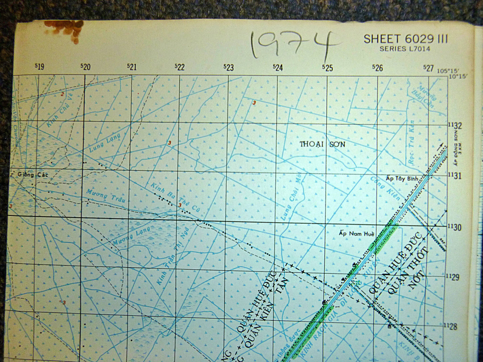
Vietnam War - Rach Gia - June 1974 - Straegically Compromised
June 1974 - Rach Gia - Gulf of Thailand - Kien Giang Province
VC Controlled - Transport Zone - Ho Chi Minh Trail
Rare - Map 6029 iii - 1974 - Rach Gia
Ho Chi Minh Trail - 1974 - Rach Gia
The June 1974 Vietnam War map titled "Rạch Giá" covers the Mekong Delta region around the provincial capital of Rạch Giá, located on the Gulf of Thailand in Kiên Giang Province (formerly part of the larger Châu Hà region).
This area, while remote from the northern battlefields, was strategically significant due to its proximity to Cambodia, extensive canal systems, and key roadways that connected economic and military routes throughout the delta.
The map features Kinh Tư Rạch Giá (a major navigable canal), Vĩnh Rạch Giá, and the coastal corridor running through Quan Hòa Đức, Quan Thới Nốt, Quan Kiên Liêu, Quan Kiên Thành, Quan Kiên Tân, and Quan Kiên Biên, local military and administrative jurisdictions in the Republic of Vietnam’s civil-military structure.
It also shows the crucial inland waterway Kinh Tư Rạch Sỏi Đến, used extensively for logistics, troop movement, and civilian trade, as well as the road LTL 80, a key land route in the region.
By June 1974, the region around Rạch Giá was under heavy pressure from Viet Cong and People's Army of Vietnam (PAVN) forces. The strategic importance of this area lay in its role as a gateway to the lower Mekong Delta and as a maritime access point to the Gulf of Thailand. Control of its waterways allowed the Viet Cong to move arms, fighters, and supplies through the intricate canal system connecting western delta provinces and nearby border zones with Cambodia.
Although Rạch Giá city itself remained under ARVN control at the time, the surrounding rural districts and canals were increasingly contested. The Viet Cong controlled large swaths of territory by night, and often by day, outside of district centres.
These contested regions saw heavy guerrilla activity, interdiction of supply routes, and efforts to isolate provincial capitals like Rạch Giá from reinforcements. By mid-1974, many outposts and hamlets in Kiên Giang Province had been overrun or abandoned, and the South Vietnamese government was relying heavily on Regional and Popular Forces with little artillery or air support.
The VC occupation of surrounding districts was part of a broader strategy in the final phase of the war to isolate and cut off urban centres, capture canal junctions, and eventually collapse the RVN’s hold over the Delta.
Though full control of Rạch Giá would not come until April 1975, by June 1974 the area was already being described in MACV intelligence reports as "strategically compromised".
The map not only charts roads and waterways but illustrates the shrinking footprint of South Vietnamese authority in one of its most agriculturally and geopolitically critical regions, with Rạch Giá poised on the edge of isolation less than a year before the war’s end.
MILITARY MAP - Very Rare
Vietnam War MAP
- Measures - 29 x 22.5 inches ( 74 x 59 cms )
- Series L 7014

Related Items:

1974 Pontiac Trans Am Formula Firebird Original Print Ad Firebird Trans Am Nice
$14.99
Boy Scouts Americas Bicentennial 1973-1977 Mixed Lot Patch Lot (5 pcs)
$25.50

1974 California License Plate Sticker, YOM, CA, DMV, Registration
$9.95